- Description
- Brill, Hes & De Graaf, 2017 Size: 315x235 mm. Full cloth with dust jacket. 692 pages, with color illustrations.
- language
- English
Early Dutch Maritime Cartography. The North Holland School of Cartography (c. 1580-c. 1620)
Schilder, Günter
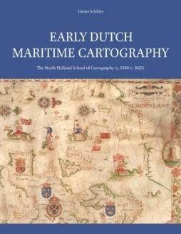
This book is an exposition of an important, yet previously unknown chapter in the history of Dutch maritime cartography. While Amsterdam was developing into Europe’s most vital commercial hub in the seventeenth century, demanding and controlling the production of maps and sea-charts, a major School of Cartography was already flourishing in the so-called ‘Kop van Noord-Holland’ region just north of Amsterdam. This School specialised in the production of small-scale charts of larger areas, including the European coastlines and the Indian and Atlantic Oceans. Its masters used to call themselves ‘caert-schrijvers’ or ‘map-scribes’ when clarifying their profession. The cities of Enkhuizen and Edam were important trading ports and as such provided an ideal environment for developing into centres of cartography, serving sea-borne navigation. Apart from the well-known printed pilot guides by Lucas Jansz Waghenaer, the output of these ‘caert-schrijvers’ consists mainly of manuscript charts on vellum. Copies, though few they are, nowadays can be found across the globe. Sea-charts provided invaluable on-board navigation assistance to ship captains. However, another surprising contemporaneous purpose for financing these charts become popular. Rich ship owners and merchants would commission new charts to serve as wall-decoration as well as a reference point for their maritime-related conversations. They feature a decorative lay-out filled with magnificent colours. Moreover, many of these charts are embellished with miniature paintings, certainly making them some of the most beautiful exemplars ever produced by Dutch cartography during its Golden Age.